Karten und Pläne
Europa
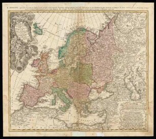
Ausführlicher Titel: Carte Générale de toute l'Europe divisée selon l'étendu de ses principaux états
Enthält u. a.:
Titel auf einfachem Postament; Maßstäbe; Randkarte mit Blatteinteilung
- Reference number
-
Abt. Generallandesarchiv Karlsruhe, 98-1 Nr. 1364
- Dimensions
-
123 x 137 cm, Stäbe 144 (Höhe x Breite)
- Notes
-
Kupferstiche in 9 Blatt; Papier auf Leinen, oben und unten auf schwarze Holzleisten geklebt
- Further information
-
Schaden: Löcher, Verknitterungen, Verfärbung in Mittelbereich
Geografische Begrenzung: Island, Kaspisches Meer, Zypern, Marokko
Herstellungsort: Augsburg
Maßstab: ca. 1:4.700.000
- Context
-
Kloster Salem: Nachträge aus Schloss Salem >> Pläne >> Gedruckte Landkarten >> Allgemein
- Holding
-
Landesarchiv Baden-Württemberg, Abt. Generallandesarchiv Karlsruhe, 98-1 Kloster Salem: Nachträge aus Schloss Salem
- Indexentry person
-
Lotter, Matthias Albert
- Creator
-
Autor/Fotograf: Lotter, Matthias Albert
- Other object pages
- Rights
-
Es gelten die Nutzungsbedingungen des Landesarchivs Baden-Württemberg.
- Last update
-
04.04.2025, 8:02 AM CEST
Data provider
This object is provided by:
Landesarchiv Baden-Württemberg. If you have any questions about the object, please contact the data provider.
Landesarchiv Baden-Württemberg. If you have any questions about the object, please contact the data provider.
Object type
- Karten und Pläne
Associated
- Autor/Fotograf: Lotter, Matthias Albert
Other Objects (12)

Europa. Karte von Europa
Europa
Europa
Europa
Europa
Europa
Europa
Europa
Europa
Europa
Europa
Europa
Europa. Karte von Europa
Europa
Europa
Europa
Europa
Europa
Europa
Europa
Europa
Europa
Europa
Europa
Europa. Karte von Europa
Europa
Europa
Europa
Europa
Europa
Europa
Europa
Europa
Europa
Europa