Archivale
Bebauungsplan Krummenhakstraße - Wörthstraße etc., Blatt 10 (nur Negativ). 1:250
- Reference number
-
59, 619.31
- Context
-
Karten des Vermessungs- und Katasteramtes >> 6. Fluchtlinienpläne, Bebauungspläne, Höhenpläne, Verbandsstraßen, Verbandsgrünflächen, Nord-Südstraße >> 619. Alte Bebauungspläne und Fluchtlinienpläne von Duisburg-Mitte
- Holding
-
59 Karten des Vermessungs- und Katasteramtes
- Date of creation
-
1878
- Other object pages
- Delivered via
- Last update
-
17.09.2025, 3:09 PM CEST
Data provider
This object is provided by:
Stadtarchiv Duisburg. If you have any questions about the object, please contact the data provider.
Stadtarchiv Duisburg. If you have any questions about the object, please contact the data provider.
Object type
- Archivale
Time of origin
- 1878
Other Objects (12)

Bebauungsplan Wanheimer Straße - Hochfeldstraße etc., Blatt 11 (nur Negativ). 1:250
Bebauungsplan Werthauser Straße - Hochfeldstraße etc., Blatt 12 (nur Negativ). 1:250
Bebauungsplan Werthauser Straße - Vulkanstraße etc., Blatt 13 (nur Negativ). 1:250
Eltville, Wörthstraße 38, Wörthstraße 40
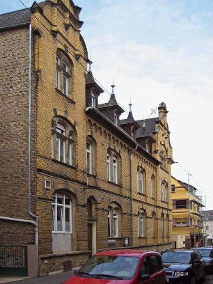
Wörthstraße
Wörthstraße
Wörthstraße
Wörthstraße
Wörthstraße

Wörthstraße
Wörthstraße
Wörthstraße
Bebauungsplan Wanheimer Straße - Hochfeldstraße etc., Blatt 11 (nur Negativ). 1:250
Bebauungsplan Werthauser Straße - Hochfeldstraße etc., Blatt 12 (nur Negativ). 1:250
Bebauungsplan Werthauser Straße - Vulkanstraße etc., Blatt 13 (nur Negativ). 1:250
Eltville, Wörthstraße 38, Wörthstraße 40
Wörthstraße
Wörthstraße
Wörthstraße
Wörthstraße
Wörthstraße
Wörthstraße
Wörthstraße
Wörthstraße
Bebauungsplan Wanheimer Straße - Hochfeldstraße etc., Blatt 11 (nur Negativ). 1:250
Bebauungsplan Werthauser Straße - Hochfeldstraße etc., Blatt 12 (nur Negativ). 1:250
Bebauungsplan Werthauser Straße - Vulkanstraße etc., Blatt 13 (nur Negativ). 1:250
Eltville, Wörthstraße 38, Wörthstraße 40
Wörthstraße
Wörthstraße
Wörthstraße
Wörthstraße
Wörthstraße
Wörthstraße
Wörthstraße