- Former reference number
-
II - 16, später: 40
- Dimensions
-
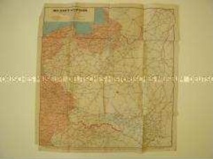
Höhe: 188 cm, Breite: 205 cm, Maßstab: 1 : 700 000
- Context
-
Allgemeine Kartensammlung (Schulwandkarten) >> 2. Erdkunde
- Holding
-
D 73 Allgemeine Kartensammlung (Schulwandkarten)
- Date of creation
-
1965
- Other object pages
- Provenance
-
Behörden, Institutionen, Einzelpersonen (Sammlungen)
- Delivered via
- Last update
-
05.11.2025, 4:32 PM CET
Data provider
This object is provided by:
Landesarchiv Nordrhein-Westfalen. Abteilung Ostwestfalen-Lippe. If you have any questions about the object, please contact the data provider.
Landesarchiv Nordrhein-Westfalen. Abteilung Ostwestfalen-Lippe. If you have any questions about the object, please contact the data provider.
Object type
- Karten / Pläne
Time of origin
- 1965
Other Objects (12)

Generalkarte von Deutschland und den Nachbarländern
Übersichtskarte der Spielbanken in Deutschland und den westlichen Nachbarländern
Politisch-geografische Karte von Polen und seinen Nachbarländern

Süd-Deutschland mit dessen Nachbarländern
Eisenbahnkarte von Deutschland und Nachbarländern
Eisenbahnkarte von Deutschland und Nachbarländern
Eisenbahnkarte von Deutschland und Nachbarländern
Geografische Karte vom Westteil Deutschlands und den westlichen Nachbarländern
Freilichtmuseen in Deutschland und seinen Nachbarländern
Automobilmuseen in Deutschland und seinen Nachbarländern
Geologische Karte von Preußen und den Nachbarländern
Karte mit politischer Übersicht von Deutschland
Generalkarte von Deutschland und den Nachbarländern
Übersichtskarte der Spielbanken in Deutschland und den westlichen Nachbarländern
Politisch-geografische Karte von Polen und seinen Nachbarländern
Süd-Deutschland mit dessen Nachbarländern
Eisenbahnkarte von Deutschland und Nachbarländern
Eisenbahnkarte von Deutschland und Nachbarländern
Eisenbahnkarte von Deutschland und Nachbarländern
Geografische Karte vom Westteil Deutschlands und den westlichen Nachbarländern
Freilichtmuseen in Deutschland und seinen Nachbarländern
Automobilmuseen in Deutschland und seinen Nachbarländern
Geologische Karte von Preußen und den Nachbarländern