Karte / Plan
Wallis, Schweiz, topographische Karte des westlichen und südlichen Teils: Partie Occidentale et Meridionale de la Suisse et Pais de Vallais. Dressée par H.M. 1795 et Terminé en 1802 / Se Vand a Geneve Chez F. Monty
- Former reference number
-
Bibliothek Harff-Dreiborn, Landkarten Nr. 66
- Dimensions
-
Höhe: 48 cm, Breite: 74 cm
- Notes
-
stark beschädigt
- Context
-
RW Karten >> 1. Topographische Karten >> 1.3. Landesaufnahme Ausland >> 1.3.3. Europa
- Holding
-
RW Karten
- Date of creation
-
1802
- Other object pages
- Provenance
-
Diverse Registraturbildner
- Delivered via
- Last update
-
17.09.2025, 3:27 PM CEST
Data provider
This object is provided by:
Landesarchiv Nordrhein-Westfalen. Abteilung Rheinland. If you have any questions about the object, please contact the data provider.
Landesarchiv Nordrhein-Westfalen. Abteilung Rheinland. If you have any questions about the object, please contact the data provider.
Object type
- Karten / Pläne
Time of origin
- 1802
Other Objects (12)
Les Annamites et l'Instructionb Occidentale.
La Chine Méridionale et Centrale. Et la Pénétration Francaise.

"MOnTY"

MoNty

Monty Python
Monty Vampir
![6: Russie Mérid[iona]le. et Turquie](https://iiif.deutsche-digitale-bibliothek.de/image/2/eb17f6a6-6aed-479e-9a02-28bd5f247e93/full/!306,450/0/default.jpg)
6: Russie Mérid[iona]le. et Turquie

Carte De L'Amérique Méridionale : Dressée En 1809, D'Après Les Cartes De La Cruz, Jefferys Et Quelques Autres Cartes Marines Et Terrerstres, Tant Manuscrites Que Gravées
2. L՚Orient et la littérature occidentale
Sauterelles, grillons et criquets d'Europe occidentale
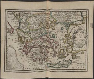
La Grece ou Partie Meridionale De La Turquie D'Europe : dressée sur les Dernieres Observations
Monty, das Erdmännchen
Les Annamites et l'Instructionb Occidentale.
La Chine Méridionale et Centrale. Et la Pénétration Francaise.
"MOnTY"
MoNty
Monty Python
Monty Vampir
6: Russie Mérid[iona]le. et Turquie
Carte De L'Amérique Méridionale : Dressée En 1809, D'Après Les Cartes De La Cruz, Jefferys Et Quelques Autres Cartes Marines Et Terrerstres, Tant Manuscrites Que Gravées
2. L՚Orient et la littérature occidentale
Sauterelles, grillons et criquets d'Europe occidentale
La Grece ou Partie Meridionale De La Turquie D'Europe : dressée sur les Dernieres Observations