Karten und Pläne
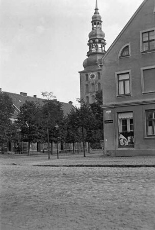
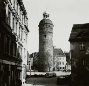
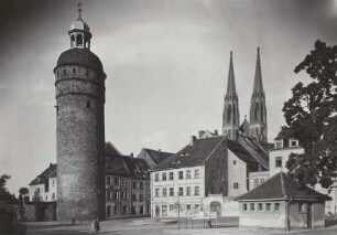
Abt. A, Bl. 4 - Überarbeitung zu Nr. 35 - Packhofstraße, Gerberstraße, Blücherplatz, Blücherstraße, Bahnhofstraße, Müller-Denkmal, Parkstraße, Plauenscher Platz, Plauensche Straße, Brühl, Hallesche Straße, Ritterstraße, Reichsstraße, Katharinenstraße, Nikolaistraße
- Reference number
-
Stplan Kanitz Nr. 44
- Dimensions
-
89,5x72,5
- Further information
-
Herstellungsvermerk: Oskar von Bomsdorff geographisch-lithographische Anstalt Leipzig
- Context
-
1.2.2.18.2.1 Stadtplan Kanitz
- Holding
-
1.2.2.18.2.1 Stadtplan Kanitz
- Indexentry place
-
Packhofstraße
Gerberstraße
Blücherplatz
Blücherstraße
Bahnhofstraße
Parkstraße
Plauenscher Platz
Plauensche Straße
Brühl
Hallesche Straße
Ritterstraße
Reichsstraße
Katharinenstraße
Nikolaistraße
Müller-Denkmal
- Date of creation
-
[1850-1892]
- Other object pages
- View digital item at providers-website
- Rights
-
Es gilt die Archivsatzung des Stadtarchivs Leipzig.
- Last update
-
13.08.2025, 9:51 AM CEST
Data provider
This object is provided by:
Stadtarchiv Leipzig. If you have any questions about the object, please contact the data provider.
Stadtarchiv Leipzig. If you have any questions about the object, please contact the data provider.
Object type
- Karten und Pläne
Time of origin
- [1850-1892]
Other Objects (12)

Abt. A, Bl. 4 - Packhofstraße, Gerberstraße, Blücherstraße, Blücherplatz, Bahnhofstraße, Plauenscher Platz, Plauenscher Straße, Parkstraße, Müller-Denkmal, Hallesche Straße, Brühl, Katharinenstraße, Reichsstraße, Nikolaistraße, Ritterstraße

Abt. A, Bl. 4 - Überarbeitung/Ergänzung zu Nr. 35 und 44 - Packhofstraße, Gerberstraße, Blücherstraße, Blücherplatz, Bahnhofstraße, Müller-Denkmal, Parkstraße, Plauenscher Platz, Plauensche Straße, Katharinenstraße, Brühl, Reichsstraße, Hallesche Straße, Nikolaistraße, Ritterstraße

Packhofstraße
Packhofstraße

Packhofstraße
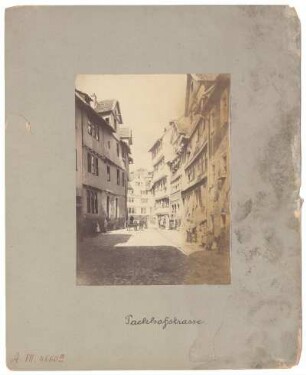
Kassel Packhofstraße
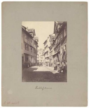
Kassel Packhofstraße

Kassel Packhofstraße
Kleine Packhofstraße

Kleine Packhofstraße
Nikolaistraße
Nikolaistraße
Abt. A, Bl. 4 - Packhofstraße, Gerberstraße, Blücherstraße, Blücherplatz, Bahnhofstraße, Plauenscher Platz, Plauenscher Straße, Parkstraße, Müller-Denkmal, Hallesche Straße, Brühl, Katharinenstraße, Reichsstraße, Nikolaistraße, Ritterstraße
Abt. A, Bl. 4 - Überarbeitung/Ergänzung zu Nr. 35 und 44 - Packhofstraße, Gerberstraße, Blücherstraße, Blücherplatz, Bahnhofstraße, Müller-Denkmal, Parkstraße, Plauenscher Platz, Plauensche Straße, Katharinenstraße, Brühl, Reichsstraße, Hallesche Straße, Nikolaistraße, Ritterstraße
Packhofstraße
Packhofstraße
Packhofstraße
Kassel Packhofstraße
Kassel Packhofstraße
Kassel Packhofstraße
Kleine Packhofstraße
Kleine Packhofstraße
Nikolaistraße
Nikolaistraße
Abt. A, Bl. 4 - Packhofstraße, Gerberstraße, Blücherstraße, Blücherplatz, Bahnhofstraße, Plauenscher Platz, Plauenscher Straße, Parkstraße, Müller-Denkmal, Hallesche Straße, Brühl, Katharinenstraße, Reichsstraße, Nikolaistraße, Ritterstraße
Abt. A, Bl. 4 - Überarbeitung/Ergänzung zu Nr. 35 und 44 - Packhofstraße, Gerberstraße, Blücherstraße, Blücherplatz, Bahnhofstraße, Müller-Denkmal, Parkstraße, Plauenscher Platz, Plauensche Straße, Katharinenstraße, Brühl, Reichsstraße, Hallesche Straße, Nikolaistraße, Ritterstraße
Packhofstraße
Packhofstraße
Packhofstraße
Kassel Packhofstraße
Kassel Packhofstraße
Kassel Packhofstraße
Kleine Packhofstraße
Kleine Packhofstraße
Nikolaistraße