Karte / Plan
[Topographische Karte Belgiens:] Saint-Vith. Imp. litho. de l'Institut Cartographique Militaire 193[3], Brüssel
- Former reference number
-
IIIter
- Dimensions
-
Maßstab: [1 : 40.000]
- Notes
-
Auf Leinwand aufgezogen
- Context
-
RW Karten >> 1. Topographische Karten >> 1.3. Landesaufnahme Ausland >> 1.3.3. Europa >> 1.3.3.2. Belgien
- Holding
-
RW Karten
- Date of creation
-
193[3]
- Other object pages
- Provenance
-
Diverse Registraturbildner
- Delivered via
- Last update
-
17.09.2025, 2:36 PM CEST
Data provider
This object is provided by:
Landesarchiv Nordrhein-Westfalen. Abteilung Rheinland. If you have any questions about the object, please contact the data provider.
Landesarchiv Nordrhein-Westfalen. Abteilung Rheinland. If you have any questions about the object, please contact the data provider.
Object type
- Karten / Pläne
Time of origin
- 193[3]
Other Objects (12)
![[Topographische Karte Belgiens, Aufnahme 1872, letzte Revision 1925-26.] Gemmenich. Imp. litho. de l'Institut Cartographique Militaire 1933, Brüssel](https://iiif.deutsche-digitale-bibliothek.de/image/2/772dda1c-6251-4646-a9b5-e282ffa2f98a/full/!306,450/0/default.jpg)
[Topographische Karte Belgiens, Aufnahme 1872, letzte Revision 1925-26.] Gemmenich. Imp. litho. de l'Institut Cartographique Militaire 1933, Brüssel
![[Topographische Karte Belgiens, Aufnahme 1872, letzte Revision 1903:] Stavelot. Imp. litho. del'Institut Cartographique Militaire 1934, Brüssel](https://iiif.deutsche-digitale-bibliothek.de/image/2/2d007bdd-8aa2-43bf-bb4a-97beab24d734/full/!306,450/0/default.jpg)
[Topographische Karte Belgiens, Aufnahme 1872, letzte Revision 1903:] Stavelot. Imp. litho. del'Institut Cartographique Militaire 1934, Brüssel

"Litho"
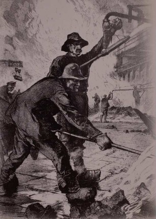
Kokereiarbeiter, Litho.
![Boieldieu, Membre de l'Institut / Lith Bernard et Delarue ; Imp. Litho. de M[a]d[emoisel]le. Formentin, rue St. André des Arts, No. 59](https://iiif.deutsche-digitale-bibliothek.de/image/2/8b6ff440-6ddf-4661-8211-7df10ea07e72/full/!306,450/0/default.jpg)
Boieldieu, Membre de l'Institut / Lith Bernard et Delarue ; Imp. Litho. de M[a]d[emoisel]le. Formentin, rue St. André des Arts, No. 59

Freital, Windbergschacht, Litho.
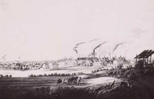
Königshütte, Hüttenwerk, Litho.
Optische Litho-Typographie
Litho Films - Chromolithographische Loops
Litho Films - Chromolithographische Loops

Litho Films - Chromolithographische Loops
Litho Films - Chromolithographische Loops
[Topographische Karte Belgiens, Aufnahme 1872, letzte Revision 1925-26.] Gemmenich. Imp. litho. de l'Institut Cartographique Militaire 1933, Brüssel
[Topographische Karte Belgiens, Aufnahme 1872, letzte Revision 1903:] Stavelot. Imp. litho. del'Institut Cartographique Militaire 1934, Brüssel
"Litho"
Kokereiarbeiter, Litho.
Boieldieu, Membre de l'Institut / Lith Bernard et Delarue ; Imp. Litho. de M[a]d[emoisel]le. Formentin, rue St. André des Arts, No. 59
Freital, Windbergschacht, Litho.
Königshütte, Hüttenwerk, Litho.
Optische Litho-Typographie
Litho Films - Chromolithographische Loops
Litho Films - Chromolithographische Loops
Litho Films - Chromolithographische Loops
Litho Films - Chromolithographische Loops
[Topographische Karte Belgiens, Aufnahme 1872, letzte Revision 1925-26.] Gemmenich. Imp. litho. de l'Institut Cartographique Militaire 1933, Brüssel
[Topographische Karte Belgiens, Aufnahme 1872, letzte Revision 1903:] Stavelot. Imp. litho. del'Institut Cartographique Militaire 1934, Brüssel
"Litho"
Kokereiarbeiter, Litho.
Boieldieu, Membre de l'Institut / Lith Bernard et Delarue ; Imp. Litho. de M[a]d[emoisel]le. Formentin, rue St. André des Arts, No. 59
Freital, Windbergschacht, Litho.
Königshütte, Hüttenwerk, Litho.
Optische Litho-Typographie
Litho Films - Chromolithographische Loops
Litho Films - Chromolithographische Loops
Litho Films - Chromolithographische Loops